Showing posts with label Oregon Trail. Show all posts

Wednesday, September 26, 2018

#virtualoregontrail The survivors reach The Dalles

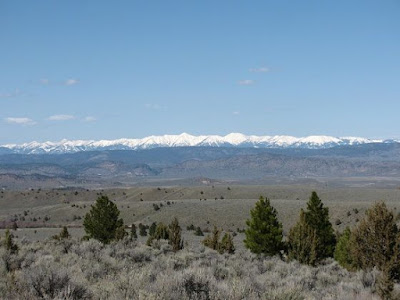
With the magnificent snow-capped peaks of the Cascade Mountains in the distance, the emigrants kept heading north towards The Dalles and the Columbia River. To get there, they would have to cross the Deschutes River. As they traveled, they searched for the best place to make that crossing. The cliffs were steep and the water very swift, so finding a safe place to lower the wagons and ferry across the river was no easy task.

On September 26th, Tetherow and Meek, along with their companies, joined with the Riggs group. It was decided that they would proceed together as one group to the Columbia beginning the following day. Many, like James Field, had contracted Camp Fever. All were hungry and in need of water. Before they left, Samuel Parker noted in a diary that six dead were buried.

For three days they traveled and then had to ascend Bull Mountain, a double-teamed ascent described as "horrendous". Along the way, 5 more dead were buried.


"The place at which we struck the Deschutes river presented the
most unfavorable place for crossing that could be imagined. 
The river is, at that point, four rods wide, flowing between 
perpendicular walls of basalt, the water very deep and the 
current very rapid." 
William A. Goulder
a trail diarist

The group found the smoothest path down and worked together to lower a wagon using drag teams. This first group down included Meek, his wife Elizabeth, and a man named Olney. They devised a system of ropes to use in crossing the river and made it to the other shore. There they borrowed horses from the Indians fishing in the canyon so they could hurry to The Dalles to secure supplies and alert the Mission and community that the wagons would soon arrive. Meek bought food, axes, ropes, and pulleys with his own money and tried to enlist help. The missionaries refused to help as they were occupied helping the local Indians, but an old mountaineer called Black Harris volunteered his service as a pilot. He returned to the canyon with the supplies purchased by Meek.

"He in company with several others, started in 
search of the lost company, whom they found 
reduced to great extremities; their provisions nearly 
exhausted, and the company weakened by exertion, 
and despairing of ever reaching the settlements." 
Joel Palmer
a trail diarist

The emigrants were encouraged by the knowledge that their journey was now near its end, and with the additional supplies, they began work immediately. They caulked the remaining wagons tightly with tar to prepare for the crossing, then lowered them to the river. Indians in the area offered their assistance, and with their help, the livestock, all the people, and the wagons were safely ferried across the Deschutes. They crossed at a place now called "Sherar's Bridge" (on today's HWY 216), a crossing which would become known as the "the most amazing feat of all". 

"Our friends, white and red, are on the opposite bank of the river 
having arrived from The Dalles, bringing axes and ropes and other 
implements and materials to assist in the task of crossing. They are 
led by a brave old mountaineer, one of the noblest...who was known 
to everybody as "Black Harris." They are soon at work improvising 
temporary floating structures and suspension bridges. Pretty soon 
and Indian is seen to plump into the river with the end of a long rope 
in his mouth, and swim over to our side. Now it is necessary for some 
of our party to be on the other side to look out for the running gear 
of the wagons that are fastened to the ropes and thus dragged through 
the water. In order to test the strength of the rope and the safety of this 
method of transit, the rope was passed around my body, just under my 
arms, and I was dragged through the raging torrent to the other side. 
I could but feel that I was in the hands of my friends, not could I be 
insensible to the fact that the water was of icy coldness, just being 
lately arrived from the snowy brow of Mt. Hood. It has been my good 
fortune to enjoy some very cool and refreshing baths, but nothing in 
my experience ever equalled this one. Several of the young men 
followed my example, while the main body of the company waited 
for more elaborate contrivances."
William A. Goulder

Sherar's Hotel and Bridge were built in the 1870s
near where the emigrants made the crossing.
http://tdwhs.nwasco.k12.or.us/wascohistory/comm/sherars/hotel.html

It took about two weeks to get the entire group across the river. Wagon by wagon, with the ill and injured going first, the train was ferried across. Once on the other side, a journey of about 30 miles remained to reach The Dalles. With so many of the emigrants ill, some close to death, this distance was still a long way to go. The suffering endured during these last weeks of the journey was indescribable. More than a dozen people died from the Camp Fever. Others died from malnourishment and dehydration. The oxen, horses and the cattle were also in poor condition. 

The last wagon finally arrived in The Dalles in mid-October. Some of the illest emigrants died in the weeks following their arrival, but others began to gain strength and recuperate. The missionaries at the Wascopan Mission tirelessly nursed the Meek party once they arrived. When well, many hired Indians to take them in canoes or on rafts down the Columbia to the Willamette River, where they continued first to Oregon City, and from there to their final destinations.

The Riggs family, which included son-in-law James Miller Allen, escaped disaster and somehow all arrived alive. James B. Riggs took his family to his claim on Salt Creek in what would become Polk County. They arrived exhausted physically and financially and then had to begin the hard work of settling the homestead.



Wednesday, September 19, 2018

#virtualoregontrail September 19-25, 1845


Diary of James Field, as published in the Willamette Farmer, continued:

Fri., 19. - Went about 22 miles, road tolerably rough much of the way, camping upon a stream in a deep, narrow glen resembling the Malheur much in character, and which we believe to be Lohum's fork of Deschutes or Falls river.

Sat., 20. - Went about eight miles, camping upon the same stream mentioned yesterday, down which we followed all day, frequently crossing it, and at one narrow pass we were obliged to follow the bed of the river for nearly a fourth of a mile.

Sun., 21. - Went about 16 miles to-day, still keeping down the river, occasionally cutting across the lowest points of the bluffs, and camping upon it again. The hills along the stream upon either hand are covered in many places with tall pines.

Mon., 22. -  Went about seven miles, keeping still down along the river, which has to be crossed every mile or two, and sometimes two or three times in a mile. Camped at the foot of a tremendous hill, which it is necessary to ascend, and which when we first came in sight of appeared to be strung with wagons from the bottom to near the top, several companies being engaged in the ascent at the same time.

Tues., 23. - Went about 12 miles, striking away from the river and camping upon a small branch of it. Had a long and hard pull in the morning to ascend the hill spoken of yesterday, but once up we felt amply repaid the trouble of climbing up by the prospect which lay before us. There were the Cascade mountains stretching along the western horizon, apparently not more than forty miles distant, forming a dark outline, varied by an occasional snow-peak, which would rise lofty and spire-like, as if it were a monument to departed greatness.

Wed., 24. - Went about 15 miles, camping at a spring in the midst of the plains, without a single landmark to tell the situation.

NOTE. - This ends the journal, and we publish below a letter from Mr. Field in regard to the latter part of the journey. - Ed. Farmer.


The Deschutes at its confluence with the Columbia
https://en.wikipedia.org/wiki/Deschutes_River_(Oregon)#/media/File:Deschutes_River.jpg

Port Chester, N.Y.,
June 3, 1879.
Friend Clarke: 
Through the kindness of my old friend, R. Weeks, of Portland, I am in receipt of three numbers of your paper, containing installments of my diary kept while crossing the plains in '45, with a request that I may complete it from memory. This it is impossible for me to do, as it was cut short by my illness with camp fever, which destroyed all memory of what transpired during the remainder of the journey. I have an indistinct recollection of crossing the Deschutes river in a wagon body caulked tight, and drawn back and forth by ropes, of being carried and laid upon a bed among the rocks that lined the river-banks where we crossed, and of arriving at The Dalles so helpless that it was necessary to lift me out of and into the wagon like a baby. Then I remember going down to the Cascades in a boat such as the Hudson Bay Co. then used on the river, of walking and crawling past the first steep rapid, then getting into a canoe with some Indians and running the remainder of the rapids to the landing place of the old Caliapooia, Capt. Cook owner and master; then of sailing down the Columbia and up the Willamette to Linton, a place on the west bank of the river below Portland, and then having the only wagon-road to the Tualatin plains below Oregon City from the river. From Linton to Oregon City I was a fellow-passenger with old Mr. Fleming, the pioneer printer, so long connected with the press at that place, and I think it was late in November when we arrived there.
When I returned here overland in the spring of '48 I deposited the diary with Capt. J. B. Riggs, of Polk county, and when I returned to Oregon in '50, finding that he had used the blank leaves in the book to keep his business accounts on, I left it with him. If it is still my property, - and I know of no reason why it should not be, - please hand it to the Society of Pioneers, of Oregon. With my compliments I herewith present it to them.
It was written up daily after all my other duties as teamster and general assistant about the camp were performed. It has never been revised by me, and I hope my old companions will overlook any errors I have made.
Your friend,
James Field.


From “The Diary of James Field” Willamette Farmer (Portland, OR, Fridays: April 18 – August 1, 1879). 
1 Aug 1879 (September 18-24 + letter from author) 

Wednesday, September 12, 2018

#virtualoregontrail September 12-18, 1845 - In search of water


Continuing with the Diary of James Field:

Fri., 12. - Went about six miles, camping upon another little spring [the newspaper cuts off at the bottom and may be missing a line or two before it continues at the top of the next column] running a short distance sinks again. The ravine looks as though a smart branch ran through it at some seasons of the year. The hills around are covered with cedars; with the exception of a plain to westward, that appears to be the case with all the country to north and west of us, as far as the eye can reach, and that appears to be to the Cascade mountains. Found two-thirds of Owensby's company still here, the remainder having gone on with the pilot and captain. A party of five men who left us last Tuesday morning to go back in search of the missing horses returned tonight bringing in nine of them which they had taken from a party of Indians, near Crooked river. The Indians appeared loth to give them up but they charged upon them and took them, running the Indians off, who they say are a miserable set of wretches with no arms but bows and arrows.

Eastern Oregon High Desert, photo by Memorey Saunders Photography

Sat., 14. - Started this morning in expectation of a long drive across the plain before us, but when about four miles from camp met Meek's wife in company with a friend, returning with the news that they had found no water as yet and requesting all who were at the spring to remain there until he found a camp and returned or sent word back for them to come on. Nothing remained for us to do but drive back to the camp we had just left, where we found Tehtero's company also, so if misery loves company here is enough of it, for this small camping spot is nearly eaten out by our own large stock of cattle and to add to all this there are some in the company nearly out of provisions.

Sun., 14. [15] - Last evening the portion of Owensby's company which were out upon the plain returned with their cattle and water kegs, having left their wagons out upon the plain seven miles from here and no water had then been found within 30 miles of them. To-day Meek ordered them to return to this place and sent an order for us to remain at this place until to-morrow morning, then let 10 or 12 men accompany him with spades and dig for water at a place he thinks it can be found, in the dry bed of a creek. This evening Owensby returned with his wagons, teams, cattle and all, having enough of lying out in the plain upon uncertainties. Meek came in after dark and said that from the top of a mountain a short distance from here he had discovered a cut in the side of a mountain apparently 15 miles distant where from the bright green appearance of the willows and grass there could be no doubt of our finding water and requesting that some horsemen might accompany him to search the mountain sides still further; he thought there would be no danger in some wagons starting to-morrow.

Mon., 15.[16] - This afternoon about three o'clock, 21 of Tethero's wagons, together with six or seven of Owensby's company, made a start for the spot spoken of yesterday, which lies northeasterly from here, Meek accompanying them. A company of eight or ten wagons passed through the hollow we are encamped in, and started out into the plains by moonlight in the evening. They were a company we had never seen before and they said they were the last to leave the States for Oregon this year, starting some two or three weeks behind us. Their loose stock were nearly all working steers, they having enough apparently to change teams every day.

Tues., 16.[17] - Capt. Riggs accompanied by the two Wilcoxs' started yesterday morning to search for water at a place they had seen the day before, and which the description given by Meek of the spot he expected to find water at, applied to precisely. They returned this morning reporting it the same with plenty of water and grass. We made preparation for starting immediately, but could not get ready until late in the afternoon, as our cattle were so scattered. We had a clear, full moon to light us on our toilsome way, which lay across a mountain to the northward, and after traveling about 20 miles we reached the long-sought spot at daybreak.

Wed., 18. - We are now nearer or as near the spring from which we made the 30-mile stretch on the 10th inst. as at the camp after we had made it, and this too after lying in vexatious suspense, cramped in a little narrow, barren, rocky hollow among the mountains, with the dry plain some 40 or 50 miles in extent before us, with the delightful anticipation that we would be obliged to cross it before reaching water. Nor was this all; more that one family had shaken the last flour from their sack, and others could calculate to a certainty the day they would do likewise. Lay by to-day wishing to get a smaller company if possible, three large ones being mixed together.

From “The Diary of James Field” Willamette Farmer (Portland, OR, Fridays: April 18 – August 1, 1879). 
25 Jul 1879 (September 8-18) 


Wednesday, September 5, 2018

#virtualoregontrail September 5-11, 1845, Following Meek across the barrens

Continuing with the diary of the driver for the Riggs' family, James Field:

Fri., 5. - Went 15 miles, camping upon the Lake fork of John Day's river. I was mistaken about our being through the Blue Mountains. Although we were through the main range, yet the road for the past few days has led across low mountains which, having their steepest descent toward the west, did not appear high until we ascended them. The map of the country we had with us also indicated that we had passed the head of John Day river, as the Malheur was made to head much further south than the John Day, and yet we have held a south south-west course from the Malheur, and are now upon the head forks of the John Day river.

Map of the Crooked River watershed, its main tributaries and downriver connection to the
Columbia River via the Deschutes River.
https://en.wikipedia.org/wiki/Crooked_River_(Oregon)

Sat., 6. - Went about 14 miles to-day, camping upon another fork of Crooked river instead of John Day as stated yesterday, and we are in fact upon the waters of Deschutes river, and steering direct toward the Cascade mountains in order to attempt a passage through them. The tale of our going down the John Day river was a mere tale of Meek's in order to get us upon this route and then take us wherever he pleased. But if he now fails to take us across the Cascades his head will not be worth a chew of tobacco to him, if what some of our men say prove true. He is with Owensby's company, which is one day's travel ahead of ours, and we make their camps every evening, where we find a note buried at the foot of a stake, stating the distance to the next camp, and the names of the streams.

The train continued over mountains until it finally came down East Cow Creek into the Harney Basin, in a region known today as the Oregon High Desert. The expression on Meek's face "changed to one of complete bewilderment, as if he were seeing the country for the first time." When trapping in this area 10 years prior, the alkaline lakes flooded a large portion of the valley. But now it was a drought year, the lakes were small and everything looked different. They continued south along the Silvies River and out into the lake-bed where they turned west. As they made their way to Silver Creek there were some in the forward company who insisted they continue west to find a pass over the Cascades. Meek wanted to follow Silver Creek to the north, but they refused to follow him. Wikipedia, https://en.wikipedia.org/wiki/Meek_Cutoff

Sun., 7. - Went about 16 miles, camping upon a lake of miserable, stagnant water, filled with ducks, geese and cranes, and surrounded with tall rushes, the borders being miry. Had excellent grass, but were obliged to pack wormwood for half a mile for fuel. During the night 15 head of horses and mules left us.

Mon., 8. - Went about 13 miles, camping upon a creek which appears to feed the lake our last camp was situated upon. We have been traveling for the last three days across a nearly dead level plain, in a south-westerly direction, and are now nearly across it, the bluffs rising abruptly from the level of the plain, which they surround, and are in many places nearly perpendicular. Many parts of this plain, particularly where we struck it, has a soil of good depth, and is covered with a very fine kind of grass resembling blue grass. Much of it is covered with that same eternal wormwood mentioned so often, and there are many places which look as though they were covered with water during the wet season, now presenting a surface of naked white clay encrusted in place with a white substance resembling saleratus and answering the same purpose, as some of the women in camp have proven by experiment. Four of the horses which left our last camp were found to-day at a distance of several miles from it, but there is no news of the others. They probably strayed off in search of water, as the borders of the lake were so miry they could not get a drink.

Tues., 9. - Last evening a child of E. Packwood, of Illinois, which had been ill a few days died suddenly. At present there are a good many sick about the camp, the majority of them complaining of fever. The child was buried in the dry wormwood barrens, and as we left the camp the wagons filed out over the grave, thus leaving no trace of its situation. The reason of our doing this was that the Indians in this part of the country are very fond of clothing, giving almost anything they possess in order to obtain it, and fearing that they might disturb the grave after we left, we took the precaution of leaving a beaten road across it. I cannot say that they would do anything to a grave were they to find one, for we have passed several evidently made by the emigrants at various times, and none of them appeared to have been disturbed. Went six miles, camping near a spring which sinks near where it rises.

Wed., 10. - The ground about our encampment is encrusted with salt, which in some places may be scraped up with the hand in nearly a pure state. Went about 30 miles to-day, over a road pretty well strewn with the hard, round nigger-heads frequently mentioned after leaving Fort Hall, and camped after midnight at a spring, where we found Owensby's company, which had arrived 24 hours before us. Their last camp was about seven miles this side of ours, and it was a dry one in the midst of wormwood barrens, so that they were nearly two days without water. We found about 200 head of their stock between the two encampments, apparently nearly famished for water, and drove them on with us, but few of them giving out on the way, although they looked miserable.

The scenic Lower Deschutes River winds through Oregon’s high desert as it flows north to the Columbia River. (Bob Wick, BLM) https://www.recreation.gov/marketing.do?goto=acm/Explore_And_More/exploreArticles/the-wild-and-scenic-lower-deschutes-river.htm

Thurs., 11. - It being 2 o'clock this morning before we got to camp, we stuck to it the remainder of the day. Owensby's company left about noon for a camp six or seven miles ahead. His company are in as much confusion as any set of fellows I have seen on the road. Having lost confidence in Meek, many of them are trying to hunt a road for themselves. It seems there was a misunderstanding between us and Meek when we left Snake river respecting the route he intended taking. We understood him that on leaving the Malheur river he intended striking over to the John Day river and down it to the old road. When we found ourselves on the branches of Deschutes river it rather surprised us, and as we had a report in camp a few days before that he was going to pilot Owensby across the Cascade mountains to the Willamette settlements, we supposed he was taking a straight shoot for them. It seems that he calls the Deschutes river the John Jay, which he says is the name by which it is known to the mountain traders, and the similarity of the two names made us mistake one for the other. It was his intention to follow down Crooked river to Deschutes and down it to the old road, but when he came to the marshy lake spoken of last Sunday, the company refused to follow him if he made the circuit necessary to get around it upon Crooked river again so he struck off in a westerly direction in order to get upon the main Deschutes river. He well knew that there was a scarcity of both grass and water across here and so informed them, but it was nearer and they would have him go it, and now blame him for coming the route they obliged him to.

From “The Diary of James Field” Willamette Farmer (Portland, OR, Fridays: April 18 – August 1, 1879). 
18 Jul 1879 (August 22-September 7) 
 25 Jul 1879 (September 8-18) 


Wednesday, August 29, 2018

#virtualoregontrail August 29 - September 4, 1845, Meek has changed his route

The Diary of James Field continues:

Fri., 29.- Went about 12 miles to-day, over mountains to which those we had previously crossed were small hills, camping near a little spring in the mountains which affords sufficient water for the use of camp, but our cattle would have been obliged to do without any had it not been for a storm of rain which came on in the evening, the first storm for months. the mountains are covered with small, black, hard, nine-cornered stones, about the size of those used to macadamize a road, and our cattle cringe at every step.

Sat., 30.- Went about 12 miles to-day, over mountains as high as any yet met with, but some of them were grassy without rocks, whilst others were covered with the big round stones so nice to jounce a wagon over, spoken of back towards Fort Hall. We camped upon a small branch and found grass and water both plenty and good, which was what our cattle stood in much need of, as for several days we have had hard roads and bad camps, which has cut down stock lower than at any time. Three or four oxen have laid down in the road and given out every day for the past few days.

Yoke of Oxen
https://www.gutenberg.org/files/29543/29543-h/29543-h.htm

Sun., 31.- Went about five miles this morning and camped once more on Malheur river near a peak in the Blue Mountains called Fremont's peak, the highest point of land in this part of the country, and easily distinguished at a great distance by a large conical rock upon its summit, having one perpendicular side to it. Found an excellent encampment again here.

Mond., Sept. 1- Went about five miles, camping again on the Malheur. The road to-day for short turns, sideling places, hard pulls and jolting stones was rather ahead of anything we have yet had in the same distance, but the camping is first rate.

Tues., 2.- Traveled about 15 miles to-day, in a direction but little west of south, camping upon a small branch of the Malheur which puts into the South fork. About four miles of our road this morning rather exceeded anything we have passed over yet for rock, they being both large and sharp, lying in a narrow ravine where there was no shunning them. We got through, however, with only one broken axle-tree and two wagon-tongues, together with some other little fixings, which was really a favorable come-off.

Wed., 3.- Went only about six miles to-day, as we were obliged to put in a new axle-tree. Camped upon the South fork of Malheur again. It is now pretty evident that Meek, the pilot who is leading the company this route instead of the old one, does not intend to fall down to the Columbia via the John Day river at all as he told them on leaving Fort Boise, for we are evidently through the Blue Mountains, and still making a south-west course. It is now said that Meek's intention is to take us over onto the head of the Willamette if he can find a place along the Cascades which will admit of the passage of wagons through, and if not we go down the Deschutes river to the Columbia.

The Malheur in Harney County
https://landingaday.wordpress.com/tag/juntura-oregon/

Thurs., 4.- Went about 18 miles, the latter part of the road being rough and rocky. Camped upon the head of a small branch of the South fork of Malheur. The mountains where we first struck them were naked and perfectly destitute of timber. Near Fremont's peak we began to see some timber upon them, and since passing that point the hills have all had more or less timber upon them, it being generally low cedar, and on reaching the top of the last hill before descending into this hollow, tall pines appeared to crown the hill-tops before us.

From “The Diary of James Field” Willamette Farmer (Portland, OR, Fridays: April 18 – August 1, 1879). 
18 Jul 1879 (August 22-September 7) 


Wednesday, August 22, 2018

#virtualoregontrail August 22-28, 1845, Riggs elected Captain and we vote to follow Meek

Continuing with the diary of James Field:

Fri., 22.- Went about 18 miles, crossing Boise river and camping on it for the last time. It is a stream of fine, clear water, some 40 or 50 yards wide, and abounds with fish, which may be seen playing in its clear waters in many places. This afternoon the road passed close along the brink of the river at a point where there was a place of considerable depth between two riffles, and it was literally alive with fish, many of them very large salmon. This river at the point we first struck it, comes out of a range of mountains between walls of perpendicular rock several hundred feet high. After passing the mountains they gradually recede from the river, leaving a narrow bottom between, and at length die away in the steep bluffs which bound the valley on either hand. The bottom is not very fertile, but still there is very fine grass in patches, and it is cut up by sloughs, apparently washed out by the spring freshets. The banks are lined with cottonwoods and willows.


Old Fort Boise, sketch by William H. Tappan.
http://www.historyglobe.com/ot/ftboise.htm 

Sat., Aug. 23, 1845. - Went four miles this morning, which took us to Fort Boise, which stands on the eastern bank of Snake river, near the mouth of the Boise. It is a small, mean-looking fort, built like the others of sun-dried mud moulded into the shape of bricks, and appears more calculated for the collection of furs from other forts than for trading in its own immediate vicinity, as there is no game there, and the Indians living in this part of the country are very poor, many of them nearly naked and living on fish and roots. It was necessary to re-cross Snake river at this place, which is here fordable, and we all got safely over during the after-noon, camping on the western bank. The Indians assisted us in crossing, showing us the ford and helping us to drive the loose cattle, in return for which a few presents pleased them greatly. The river is near half a mile wide, and so deep as to run over the tops of the wagon sides in places, but as it was generally of uniform depth all the way across, the current was not so rapid as at the other crossing.

Sun., 24. - The story of the murder of two Frenchmen by the Walla Wallas is pronounced a humbug by the people of the fort. They say that the Walla Wallas entertain a hostile feeling towards us, and will probably try to injure us as we pass through their territory, but their numbers or equipments would not render them dangerous to such sized companies as we are at present. Still, the nature of the country is such that if they took advantage of it they could damage us considerably. We had traveled thus far as three companies without any general commander, and previous to our starting this morning it was agreed to choose one. Accordingly, James B. Riggs, our own old captain, was elected captain of the whole by a unanimous vote. A man named Meek has engaged to pilot the leading company, Capt. Owensby's, which is the only one now ahead of us. He was to guide the outfit through to the Dalles of the Columbia river by a new and near route, following the pack trail from Fort Boise and missing the Walla Wallas altogether, leaving Fort Walla Walla on his right and cutting off between 100 and 200 miles' travel. A vote was taken whether we should follow them or keep the old way, and a majority decided upon the new one. We traveled about 16 miles, camping upon Malheur creek, near the forks of the two roads.


Stephen Meek (1807-1889)
https://en.wikipedia.org/wiki/Stephen_Meek

Mond., 25.- ___ about 11 miles across the h___ ___ing on Malheur river again. Since crossing to this side of Snake river again the road has been fearfully dusty. In fact, a person who has never traveled these wormwood barrens can form no idea as to what depth dust may be cut up in them by a few wagons passing. To a person walking in the road it is frequently more than shoe deep, and if the wind happens to blow length-wise with the road, it raises such a fog you cannot see the wagon next in front.

Tues., 26. - Went about ten miles, still keeping up Malheur, crossing and re-crossing it twice, and camping upon it. We were obliged to take to the bluffs to get across several narrow bends of the river, and we there found some as hard road as any we have yet traveled. Indeed, I begin to think wagons can go anywhere.

Wed., 27.- Went about 18 miles to-day. The road, although leading across bluffs which in a country where mountains are a rarity would pass for pretty good sized ones, was tolerably fair, but there is an abundance of small, sharp stones in it, black and hard as iron, and very wearing to the feet of the cattle. We camped upon Carter's fork, from its appearance a branch of Burnt river.

Thurs., 28.- Went about six miles, camping upon the same branch as before. The sharp stones spoken of yesterday we more plentiful to-day, and a few more such days' travel as this will entirely use up our cattles' feet.

From “The Diary of James Field” Willamette Farmer (Portland, OR, Fridays: April 18 – August 1, 1879). 
11 Jul 1879 (August 11-22) 

18 Jul 1879 (August 23-September 7)